Saturday, April 30, 2016

Day 8, Friday, April 29 - Kennedy Space Center, FL to Florida City, FL

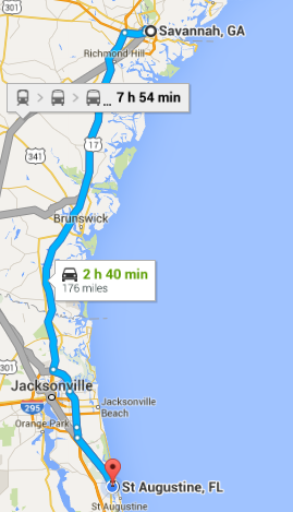
Starting mileage:  1514 Starting time: 3:30 pm

Ending mileage: 1785 Ending time: 8:00 pm
Travel mileage:  271 Travel time: 4:30 hours

We were pleasantly surprised at how interesting the Kennedy Space Center was. The size of the Saturn V rocket that sent the astronauts to the moon is almost unimaginably large and had so many parts that all had to work perfectly. There was also a great 3D IMAX movie movie about the earth narrated by Jennifer Lawrence and the International Space Station astronauts about their perspective of the earth below. It was very striking to see the night-time images of South Korea next to North Korea - bright lights vs complete darkness.

We were worn out before we had seen everything!

The trip down wasn't bad until we got to the Miami area where it was very congested. Like driving around Los Angeles but with much worse drivers. Three cars crashed into each other just beside us but we weren't able to stop.

Day 8 route
Apollo 14 Lunar Module

"smaller" Saturn I rocket


Thursday, April 28, 2016

Day 7, Thursday, April 28 - St. Augustine, FL to Cocoa Beach, FL

Starting mileage:  1385 Starting time: 12:00 pm

Ending mileage: 1514 Ending time: 3:00 pm
Travel mileage:  129 Travel time: 3:00 hours (including lunch!)

In the morning we walked to the Visitor Center and got more information about the historical aspects of the town which was founded in 1565, long before any of the English settlements. 

As a Spanish settlement, this was the opposite of Savannah and Charleston. The non-Spanish and non-Catholics were not trusted. Non-Catholics could not be buried in the Catholic cemetery and a separate place had to be found for them - it is called the Huguenot cemetery although it didn't actually have Huguenots buried there - it was a generic term for non-Spanish.

In a battle with French forces to the north, all non-Catholics were killed, not too different from current conflicts in the middle-east.

We visited Castillo de San Marcos National Park which is the original fort built in the 1600s as a wood fort and then in the 1700s as a stone fort. It is interesting in that it is built of coquina stone which is a soft stone composed of seashells.   It has the advantage that when hit with cannonballs, it compresses and absorbs the cannonball rather than shattering like a granite or other hard stone. It was never possible for sieging forces to break into the fort although they did burn and destroy the town outside.

St. Augustine changed hands a number of times, going from Spanish to English to Spanish and then to American. The occupants often changed their allegiance depending on who was in charge.

We did a walking tour of the town and were able to enjoy many historical sites, including the Cathedral, parks and buildings from the 18th and 19th centuries.

On the way down to our hotel we stopped at the Fort Mantanzas National Monument at the site of a Spanish fort that protected the "back" entrance to St. Augustine. There was a delightful picnic area under the live oak covered with Spanish moss where we had our lunch.

We are staying at a Comfort Inn in Cocoa Beach with a great view of the ocean. We were able to walk in the warm water - didn't swim as we didn't put our suits on before going to the shore.

Day 7 route

At Castillo de San Marcos


Cathedral at Constitution Square

Day 6, Wednesday, April 27 - Savannah, GA to St. Augustine, FL

Starting mileage:  1136 Starting time: 3:00 pm

Ending mileage: 1385 Ending time: 6:30 pm
Travel mileage:  251 Travel time: 3:30 hours

Our day in Savannah was similar to Charleston but reversed.

In the morning we took a trolley tour of Savannah. Savannah was founded by General James Oglethorpe in 1733, considerably later than Charleston although they have competed ever since. Savannah was laid out in a very organized fashion with streets at right angles and 24 open squares after an English design although I don't recall seeing this design in England. It is similar to Charleston and New Orleans in having French, Victorian and other "quarters". Savannah businessmen became wealthy from port trade as well as plantations for rice, indigo and cotton. There are numerous mansions which have been restored and are open to the public as museums.

When Oglethorpe founded Savannah, he prohibited lawyers, Catholics, slavery and "strong" drink. Catholics were suspected of being supporters of Spain, the main enemy of England. Unfortunately, the ban on slavery didn't last once Oglethorpe left. On the positive side, they allowed Catholics - I'm not sure about the lawyers.

Many movies have been filmed in Savannah including Forrest Gump and we went by the square where he was sitting on a bench. (The bench has been moved to a museum for safe-keeping)

In the afternoon we took a Savannah river cruise. It is interesting that we were told that Savannah is the 2nd busiest port on the east coast while in Charleston we were told that city was the busiest port on the east coast!

We've been fortunate to have good weather on our trip except for a brief thunderstorm last Saturday.

The drive to St. Augustine was only about two hours. Much of it is through heavily forested land and marshy areas with very little development

On arriving here we were disappointed that St. Augustine seemed more amusement oriented with Ripley's "Believe it or Not", wax museum, mini-golf, etc


Day 6 route
Live oak with Spanish moss

Wednesday, April 27, 2016

Day 5, Tuesday, April 26 - Charleston, SC to Savannah, GA

Starting mileage:  1054 Starting time: 4:00 pm

Ending mileage: 1136 Ending time: 6:30 pm
Travel mileage:  82 (can't be right) Travel time: 2:30 hours

Our first stop was the National Park Service Fort Sumter visitor center where there was an extensive exhibit of the history of Charleston from its founding in 1670 through the Civil War. The only access to Fort Sumter is via ferry from the visitor center. 

On the ferry going over, two dolphins were playing just at the bow of the ferry. We could see them just below the surface and then they would jump up and crash back into the water. They were so close they splashed the people standing in the very front of the ferry.  It was quite exciting to watch.

One of the first battles of the Revolutionary war was on a Charleston island where the militia was able to hold off the British attackers in large part due to the Palmetto Palm palisade around the fort which caused the cannon balls to bounce off and the militia then fired back the same cannon balls at the British, damaging their ships.  This is the reason the South Carolina flag (and license plates) has the Palmetto Palm on it.

Fort Sumter was built after the Revolutionary War to hold off foreign attackers from the sea and was a three-story structure. After the succession of South Carolina in 1860, the union forces held Fort Sumter  but were attacked by the confederate forces from the land which was the weaker side of the fort and the union forces were forced to evacuate (not quite surrender). The confederates held the fort until almost the end of the Civil War but it was reduced to a single story of rubble.

The fort has been restored to its single story level. When the fort is opened for tourists in the morning, one of the first acts is to raise the huge flag over the fort with the help of the visitors - it is a rather emotional experience. There are many informational exhibits and a visit to the fort is certainly worthwhile.

In the afternoon we took a coach tour of Charleston to see many of the historic buildings going back to the 1700s and 1800s. Many were restored after the Civil War and a major earthquake in 1898. At the end of the tour we visited the Charleston Museum which is the oldest museum in the US. We hadn't realized the importance of rice to the South Carolina economy but this is what created much of the wealth of the early landowners although it could only be done with the help of many slaves as it was very labor intensive. The end of slavery was largely responsible for the decline in rice production.

On the drive to Savannah, we were surprised by how undeveloped much of the state is - it was almost like going through the Adirondacks with miles and miles of forest with no houses - although it is VERY flat. Along the way we saw a sign for boiled peanuts and peach cider and had to stop. The peach cider was very good although sweet. A sampling of the boiled peanuts convinced me this wasn't something I wanted to buy!

We had a delicious seafood dinner at the Shrimp Factory in Savannah.

Day 5 route

Approaching Fort Sumpter

Raising the flag

Monday, April 25, 2016

Day 4, Monday, April 25 - Durham, NC to Charleston, SC

Starting mileage:  744 Starting time: 11:30 am

Ending mileage: 1054 Ending time: 4:30 pm
Travel mileage:  310 Travel time: 5:00 hours

After a relaxing breakfast with Bill and Debbie  and doing laundry, we set out for Charleston.

Fortunately, the weather is still good and the traveling down I-85. There were a number of places along the highway where different wildflowers were in bloom, mostly orange poppies and white daisies but also some blue flowers that we couldn't identify.

We are staying at a Quality Inn in Mount Pleasant, just across the river / bay from Charleston. 

We had a delicious dinner at Pearlz in the Charlestown French Quarter. Carmen had shrimp and grits which is a local specialty while I had a mixed grill with scallops, swordfish, mahi-mahi and monkfish over risotto which was very good. Afterwards we walked around the French Quarter to see some of the historic buildings and churches. Some of the streets are paved with rounded cobblestones, not the rectangular cut stones.

Day 4 route

Ravenel Bridge in Charleston
our hotel was by the right end

Day 3, Sunday April 24 - Williamsburg, VA to Durham, NC

Starting mileage:  550 Starting time: 2:00 pm

Ending mileage: 744 Ending time: 5:30 pm
Travel mileage:  196 Travel time: 2:30 hours

Morning at the hotel was chaotic as there were 200 members of a school chorus staying there, all trying to have breakfast at the same time and then checking out.

We decided to visit "Historic Jamestown" which is a National Park Service facility on the original Jamestown Island.  There is also a nearby "Jamestown Settlement" which is a commercial recreation of life in the Jamestown of 1607.

The tour guide was very good, sharing considerable history that was new to us.  We hadn't realized that John Smith had produced detailed maps and written detailed books about the original settlement. Although a lot had been written, the actual location of the 1607 fort wasn't discovered until 1994 when an archaeologist had a new theory about the location. Hundreds of thousands of artifacts were found as well as a number of graves. The artifacts and updated historical information are in a new museum on the grounds.

We had a nice picnic lunch on the grounds before driving on a loop around the island which many informational signs. We were glad to be there before the mosquitos came out!

We had planned to take the Interstate to Richmond and then down to Durham but we saw the ferry crossing the James River near Jamestown and decided to take it across instead, making the trip much shorter in miles although not much shorter in time. It was considerably more interesting and we could see the many different species of seabirds along the ferry piers.

We stayed with our friends Bill and Debbie Brooks. I had worked with Bill for several years at IBM Kingston. We had been good friends and had kept in touch regularly.

Day 3 route
Ferry from Jamestown

Pocahantas at Jamestown


Saturday, April 23, 2016

Day 2, Saturday April 23 - Ocean City, MD to Williamsburg, VA

Starting mileage:  355 Starting time: 8:30 am

Ending mileage: 550 Ending time: 3:30 pm
Travel mileage:  195 Travel time: 7:00 hours

It was nice to walk out of the room and go to the beach first thing in the morning and a comfortable 65 degrees. The waves were still crashing in but it wasn't as windy as the day before. Although the room was great, the hotel utility room was just under our room and made awful noise most of the night so I didn't get much sleep. When I complained at the front desk in the morning they gave back 50% of the room cost which lessened the pain.

Along the highway there were many trees that had what appeared to be Wisteria vines with large clusters of purple flowers - it reminded us of the Wisteria in Japan.

We went over the Chesapeake Bay bridge and tunnel back to the mainland. It is so long that we couldn't see the other end when we started on the bridge. Most of it is just supported on piers in the shallow water. In two spots there are tunnels where the ends are on artificial islands that had to be built up to have a place to descend. The tunnels had to be under water deep enough for large navy and commercial ships to pass over.

Carmen spent several years in Newport News when she was around 7 years old and she wanted to see what it was like, especially the Huntington Park. We were able to find the park and checked out the fishing pier where she and her brother used to go. We had a picnic lunch in the park overlooking the James River. We also visited the Virginia War Museum in the park. When Carmen was last there, the Vietnam, Kuwait, Afghanistan and Iraq wars had not yet taken place. The museum was very up to date, covering history up through the 2014 announcement of troops leaving Afghanistan.

We are spending the night at a Comfort Inn in Williamsburg and had dinner at the Red Hot & Blues restaurant which was very good and good value.

Day 2 route

Carmen at the Virginia War Museum

Friday, April 22, 2016

Day 1, April 22, 2016 - Home to Ocean City, MD

Starting mileage:  Starting time: 9:00 am

Ending mileage: 355 Ending time: 5:00 pm
Travel mileage:  355 Travel time: 8:00 hours

Although there were a few sprinkles before we left, it was mostly dry with temperature around 80 much of the way down.

Driving through New Jersey, we noticed that the trees had leafed out considerably more than at home. Unfortunately, there were many signs of tent caterpillar infestation in the trees along the highway and almost all the leaves had been eaten off  It was difficult to tell what species of tree they preferred.

We decided to take the route along the Delaware shore barrier island from Rehoboth beach down to Ocean city. Along the way we stopped near two of the WW 2  concrete observation towers that were used to look for German ships that might attack the shipyards up the Delaware river. The towers were only expected to last 20 years but they are still solid 75 years later.

It is pleasant being here off-season as it is not nearly as congested as the summertime when the beaches and resorts are packed. We came here when Amy and Anna were small to see the ponies at Chincoteague and it was crazy busy. We splurged and got a hotel room right next to the beach - we can walk out of our room and over the dune to the water.

Day 1 route

 Beach outside hotel in Ocean City

WW2 Observation Tower