Saturday, May 7, 2016

Day 16, Saturday, April 7 - Martinsburg, WV to home

Starting mileage:  3743 Starting time: 8:00 am

Ending mileage:  4077 Ending time: 5:00 pm
Travel mileage:   334

We've come to the end of our trip.

It has been a great trip and the weather has been almost perfect up until the last two days.

We were able to check off many items on our bucket list and have other interesting experiences by chance:
Newport News, VA - visited Carmen's childhood area
Historic Jamestown colony
Charleston, SC
Savannah, GA
St. Augustine, FL
Kennedy Space Center
Everglades
Key West, FL
Smoky Mountains
Blue Ridge Parkway
Shenandoah Park
Luray Caverns

Day 16 route


Friday, May 6, 2016

Day 15, Friday, May 6 - Roanoke, VA to Martinsburg, WV

Starting mileage:  3498 Starting time: 8:00 am

Ending mileage:  3743 Ending time: 5:00 pm
Travel mileage:   254

We planned to take the Skyline Drive through Shenandoah National Park but when we got to the southern entrance it was a bit foggy and traveling up the mountains, the fog became more and more dense. At most of the scenic overlooks visibility was zero although a couple times we could see into the distance.  Along the way we saw numerous signs of forest fire, some of which must be quite recent as the ground was completely black. We decided to bail out as soon as we could and go directly to the Luray Caverns which I had wanted to visit since I was a child.

The Luray Caverns are one of the largest in the eastern US and are truly spectacular.  The tour takes a little over an hour and covers over a mile underground. One of the most amazing is a reflecting lake where it looks like you are seeing stalactites under the water when they are actually a perfect reflection. We both enjoyed the tour.  There is also an adjacent car museum which has some of the first cars and engines made, from converted horse wagons to luxurious Rolls-Royce and Mercedes cars from 1910 - 1920. This was more interesting than we expected.

This was a good activity for a rainy day although not so good for a picnic lunch which we ate inside the car in the parking lot. It rained steadily all the way to our hotel in Martinsburg.

The clerk at the hotel recommended Boyd's Steakhouse in downtown Martinsburg. It is decorated as a "speakeasy" and has numerous items from Al Capone, including his bar and hutch. Carmen had salmon and I had scallops, both of which were very good.

 Day 15 route

Dogwood at scenic overlook on Skyline Drive
Inside Luray caverns


Day 14, Thursday, May 6 - Ashville, NC to Roanoke, VA

Starting mileage:  3164 Starting time: 9:00 am

Ending mileage:  3498 Ending time: 6:30 pm
Travel mileage:   334

When the weather forecast last night said chance of snow, we didn't believe it. Little did we know...

We got back on the Blue Ridge Parkway in Asheville and went to the visitor center which had interesting information on the parkway which was started in 1933 as part of the WPA but wasn't actually completed until the 1980s.

On the way up to Mt. Mitchell, elev 6684, the highest peak on the east coast, we started to see light snow on the ground and the trees were covered with frost. As we got near the top, there was heavy fog, blowing wind and everything was coated with frost. It is only a short walk from the parking lot to the top of the mountain but with the temperature at 30 degrees and the wind, we didn't have enough clothes to go there.

Back along the parkway at lower elevations, we saw many dogwoods in full bloom, fire azaleas, rhododendron and carpets of white, pink and red trillium.  There were spectacular views of the valley below.

We took a short walk into Linville Falls where one can clearly the the fault line of the tectonic plates, with billion year old gneiss on top of 550 million year old quartzite and 300 million year old crushed rock in between the layers. Linville Falls is named for a hunter/trapper who was killed by indians in the 1800s. There is a mining and minerals museum that is quite interesting - we didn't realize that there was so much mining in the area for feldspar, quartz, iron, mica, gold and other materials - most of them depleted at this point.

Traveling along the parkway is very scenic but also very slow and we wanted to get to Roanoke before too late.  When we left the parkway, Vicky wanted us to go down a road that didn't exist and persisted in wanting us to make u-turns to go back there. We navigated using the map and saw a sign that someone put up saying "welcome to GPS hell" - we must not be the first people with this problem.  On the way to Roanoke we had heavy rain for several hours, the first of our trip.

We wanted to celebrate Cinco de Mayo and asked the hotel clerk for a Mexican restaurant recommendation. We went to the recommended restaurant but it looked like many other people had the same idea as there was a huge crowd waiting. We went to the adjacent Ruby Tuesday instead for margaritas and queso with chips.


Day 14 route

Frosty conditions at Mt. Mitchell

View from Blue Ridge Parkway

Linville Falls (upper)


Thursday, May 5, 2016

Day 13, Wednesday, April 4 - Locust Grove, GA - Asheville, NC

Starting mileage:  2871 Starting time: 9:00 am

Ending mileage: 3164 Ending time: 5:30 pm
Travel mileage:  293

We decided to take the route north around Atlanta to avoid the traffic although Vicky (our GPS) kept on trying to put us on the Interstate beltway. We prevailed!

The terrain was similar to traveling in Dutchess county, low rolling tree-covered hills with horse farms. There were small quaint towns and ugly sections of strip malls. Lots of churches and many more baptist churches.

As we went through northern Georgia and entered North Carolina, it was more like Ulster county with higher wooded hills. The rhododendrons were in full bloom. We stopped at the Smoky Mountains information center to have a picnic lunch. It was nice to have cooler temperatures and it was comfortable sitting in the sun.

The town of Cherokee is just outside the Smoky Mountain National Park in an indian reservation that borders part of the park. This is the last commercial area and has many souvenir shops, restaurants and hotels - a bit tacky.

Just inside the park we stopped at the park visitor center to use the facilities and get our bearing. We decided to drive up to Clingmans Dome which is the highest mountain in the park at 6640'. It is a very winding route through heavy forest, in many places lined with wild rhododendron although not yet in bloom. While the trees at the bottom are fully leafed out, at the top they were not even starting - quite a contrast. It was also much colder, 44 degrees at the top while it was 64 degrees at the visitor center. There is quite an expansive view of the mountains from the parking lot at the top. We decided not to walk up to the observation tower as we needed to get to Asheville before too late.

On the way down we stopped at a restored grist mill that is still being used to grind corn into corn meal which one can purchase there. It still uses the same mill stones from the early 1900s. It is an example of an early mill which was partially automated, using a water turbine to run belts for an elevator bringing up grain, sorting it and then dropping it into the mill stones.

As we came out from the grist mill we saw two elk along the side of the road - quite exciting.

From there we got on the starting point of the Blue Ridge Highway which we took for about 20 miles but not all the way to Asheville. It is very winding and there are quite a few short tunnels - the views were exceptional.

In Asheville we met our friend David Anderson who is the organist and music director at St. Mark's Lutheran Church. We knew him at our church in Woodstock since he was just a few years old - he is two years older than Amy. We had dinner at an interesting small restaurant in Asheville.

One of our headlights was burned out but fortunately we had an extra bulb and I was able to replace it at the hotel.

Day 13 route

David Anderson at St. Mark's Lutheran Church

View from Clingman's Dome

Grist Mill


Wednesday, May 4, 2016

Day 12, Tuesday, May 3 - Fort Myers, FL to Locust Grove, GA

Starting mileage:  2323 Starting time: 8:00 am

Ending mileage: 2871 Ending time: 5:30 pm
Travel mileage:  548

Traveling to north Florida we finally started going through the first non-flat areas since entering Florida a few days ago.  The only "hills" we encountered were landfills!

Along the road there were beautiful patches of wildflowers, pink, white and yellow although we couldn't identify what they were. After entering Georgia, there were patches of purple wildflowers which we couldn't identify either.

Other than stopping for lunch, today was mainly a driving day to get north toward the Smokey Mountains.

Day 12 route


Tuesday, May 3, 2016

Day 11, Monday, May 2 - Key West, FL to Fort Myers,FL

Starting mileage:  2026 Starting time: 8:00 pm

Ending mileage: 2309 Ending time: 4:00 pm
Travel mileage:  283

We left Key West fairly early to start our trek back to Woodstock.

We stopped at the northern entrance to the Everglades park at Shark Valley where we had lunch before going on a short boardwalk through the mangroves. We decided not to take the narrated trolley tour as the birds are mostly gone by afternoon and we had already seen enough alligators which are usually seen sleeping in the afternoon.

Just one or two feet change in elevation can make the difference between a sawgrass marsh and hammock of pine, gumbo-limbo and palm trees. The clusters of trees look like islands in a sea of sawgrass.

We took a short foray  into the Big Cypress National Preserve which is next to the Everglades. While the Everglades are mainly fed by water that drains down from Lake Okeechobee and above, Big Cypress is dependent largely on rainfall that it receives directly. The ecology is quite different as it is mostly cypress in standing water. It is also the home of the Florida panther which is quite elusive. We went through a number of charred areas which had recent fires but were now starting to come back. 

We are staying in Fort Myers tonight.
Day 11 route

Boardwalk through the mangroves at Shark Valley visitor center
Cypress swamp

Palm recovering from fire


Monday, May 2, 2016

Day 10, Sunday, May 1 - Florida City, FL to Key West, FL

Starting mileage:  1885 Starting time: 9:000 pm

Ending mileage: 2017 Ending time: 12:30 pm
Travel mileage:  132 Travel time: 3:30 hours

It is quite a spectacular drive out the chain of Florida Keys. The Keys are linked together by a series of 42 bridges and causeways, some of them several miles long. The longest runs for 7 miles along the remains of an ill-fated railroad track from the early 1900s which was destroyed by a hurricane in 1933.

The shallow water is a brilliant aqua color, dotted with small islands (keys) and mangroves. Many of the causeways are lined with mangroves.

Many of the keys are famous for the scuba diving and fishing. Key Largo is said to be the world capital for skin diving. Surprisingly there aren't many beaches along the keys.

Wandering into Key West, we found a small park near the shore where we had a picnic lunch. There are chickens running wild all over the island, the descendents of chickens that were brought here in the late 1800s from Cuba for cockfighting. When the authorities decided to tax cockfighting, many chickens were let go and when cockfighting was made illegal, even more were given their freedom. One rooster crowed at us regularly and begged for treats - he enjoyed the bits of apple and Triscuit but not the pita chips!

While we were eating lunch Carmen saw a large (!) iguana walking across the bocce court next to us so I rushed to take a photo.  Iguanas are very common in Key West and we saw many more of different sizes.

We took a trolley ride around town as the easiest way to discover the  important features of Key West.  This took us by the southern-most point of the US (many people lining up to take photos next to it), Hemmingway's house, Truman's little white house and many historic buildings. Key West was originally purchased for $2000 (this would only buy a few square feet today - prices are the same as Manhattan). At one point Key West was the biggest city in Florida and and one of the richest in the US - the main economy in the late 1800s was salvaging valuables from the many ships that were wrecked in the shallow water off Key West.

We later drove back downtown for dinner and to watch the famous sunset in Key West with thousands of our new friends. There were many vendors, fortune tellers and street performers to entertain a significantly inebriated crowd.

Day 10 route

Postcard Carmen

Iguana, about 3' long

Sunday, May 1, 2016

Day 9, Saturday April 30 - Florida City, FL & Everglades

Leon,alligators
Fire
boat trip, crocodile
We spent all day Saturday in the Everglades, traveling to Flamingo at the very end.

At the visitor center we were recommended to take the nature walk with Ranger Leon along the Anhinga Trail and we were quite glad we did.

Leon was quite an engaging character, very knowledgeable and philosophical. This past winter was the wettest in history which had a major impact on what one could see this time of year. Winter is usually the "dry" season when the water levels go down and the alligators, fish, birds and other wildlife are forced to congregate in the remaining pools of water. But this year the water levels didn't go down so the concentration didn't occur.

Leon was beginning to despair that we wouldn't see any alligators but at the end of the boardwalk, we saw a large alligator swimming toward shore and then another. Then one of the alligators started to "bellow" and the other responded - male alligators do this during the mating season which is this time of year. Then a 3rd very large alligator swam right to the platform where we were standing - quite exciting.

There have been many water management mistakes over the past 100 years which have been very detrimental to the condition of the Everglades. From the 1930s to 1960s, there was major water drainage and diversion for agriculture which greatly reduced the water flow into the Everglades, causing it to dry and reduce the habitat. In the 1980s, the US Corps of Engineers started to undo their previous efforts and restore the water flow which is improving the conditions in the Everglades which has been helpful. As one can imagine, there are many financial and political complications doing this.

A major fire had just been put under control although some areas of the park were closed. We could see burned trees for several miles along one side of the road. Fires are often allowed to burn as this is necessary for the health of the park - they mainly intervene to protect buildings.

At Flamingo we took a boat tour into the "back country", up the Buttonwood Canal. This was another case of misguided engineering. The canal was dug from the ocean to an inland bay to improve access but as a consequence, it let in salt water at high tide and let out nutrient laden fresh water at low tide causing algae blooms and dramatically changing the vegetation.  It took 30 years to come up with a solution which was to build a dam separating the canal from the ocean and putting a marina on the fresh water side.  The ecology is starting to come back.  There are dense mangroves all along the canal and inland waterways. We were able to see one small American Crocodile, an endangered species that only resides in this area of the US. (It does reside also in Central and South America). 

Aligator about 11 feet long


Saturday, April 30, 2016

Day 8, Friday, April 29 - Kennedy Space Center, FL to Florida City, FL

Starting mileage:  1514 Starting time: 3:30 pm

Ending mileage: 1785 Ending time: 8:00 pm
Travel mileage:  271 Travel time: 4:30 hours

We were pleasantly surprised at how interesting the Kennedy Space Center was. The size of the Saturn V rocket that sent the astronauts to the moon is almost unimaginably large and had so many parts that all had to work perfectly. There was also a great 3D IMAX movie movie about the earth narrated by Jennifer Lawrence and the International Space Station astronauts about their perspective of the earth below. It was very striking to see the night-time images of South Korea next to North Korea - bright lights vs complete darkness.

We were worn out before we had seen everything!

The trip down wasn't bad until we got to the Miami area where it was very congested. Like driving around Los Angeles but with much worse drivers. Three cars crashed into each other just beside us but we weren't able to stop.

Day 8 route
Apollo 14 Lunar Module

"smaller" Saturn I rocket


Thursday, April 28, 2016

Day 7, Thursday, April 28 - St. Augustine, FL to Cocoa Beach, FL

Starting mileage:  1385 Starting time: 12:00 pm

Ending mileage: 1514 Ending time: 3:00 pm
Travel mileage:  129 Travel time: 3:00 hours (including lunch!)

In the morning we walked to the Visitor Center and got more information about the historical aspects of the town which was founded in 1565, long before any of the English settlements. 

As a Spanish settlement, this was the opposite of Savannah and Charleston. The non-Spanish and non-Catholics were not trusted. Non-Catholics could not be buried in the Catholic cemetery and a separate place had to be found for them - it is called the Huguenot cemetery although it didn't actually have Huguenots buried there - it was a generic term for non-Spanish.

In a battle with French forces to the north, all non-Catholics were killed, not too different from current conflicts in the middle-east.

We visited Castillo de San Marcos National Park which is the original fort built in the 1600s as a wood fort and then in the 1700s as a stone fort. It is interesting in that it is built of coquina stone which is a soft stone composed of seashells.   It has the advantage that when hit with cannonballs, it compresses and absorbs the cannonball rather than shattering like a granite or other hard stone. It was never possible for sieging forces to break into the fort although they did burn and destroy the town outside.

St. Augustine changed hands a number of times, going from Spanish to English to Spanish and then to American. The occupants often changed their allegiance depending on who was in charge.

We did a walking tour of the town and were able to enjoy many historical sites, including the Cathedral, parks and buildings from the 18th and 19th centuries.

On the way down to our hotel we stopped at the Fort Mantanzas National Monument at the site of a Spanish fort that protected the "back" entrance to St. Augustine. There was a delightful picnic area under the live oak covered with Spanish moss where we had our lunch.

We are staying at a Comfort Inn in Cocoa Beach with a great view of the ocean. We were able to walk in the warm water - didn't swim as we didn't put our suits on before going to the shore.

Day 7 route

At Castillo de San Marcos


Cathedral at Constitution Square

Day 6, Wednesday, April 27 - Savannah, GA to St. Augustine, FL

Starting mileage:  1136 Starting time: 3:00 pm

Ending mileage: 1385 Ending time: 6:30 pm
Travel mileage:  251 Travel time: 3:30 hours

Our day in Savannah was similar to Charleston but reversed.

In the morning we took a trolley tour of Savannah. Savannah was founded by General James Oglethorpe in 1733, considerably later than Charleston although they have competed ever since. Savannah was laid out in a very organized fashion with streets at right angles and 24 open squares after an English design although I don't recall seeing this design in England. It is similar to Charleston and New Orleans in having French, Victorian and other "quarters". Savannah businessmen became wealthy from port trade as well as plantations for rice, indigo and cotton. There are numerous mansions which have been restored and are open to the public as museums.

When Oglethorpe founded Savannah, he prohibited lawyers, Catholics, slavery and "strong" drink. Catholics were suspected of being supporters of Spain, the main enemy of England. Unfortunately, the ban on slavery didn't last once Oglethorpe left. On the positive side, they allowed Catholics - I'm not sure about the lawyers.

Many movies have been filmed in Savannah including Forrest Gump and we went by the square where he was sitting on a bench. (The bench has been moved to a museum for safe-keeping)

In the afternoon we took a Savannah river cruise. It is interesting that we were told that Savannah is the 2nd busiest port on the east coast while in Charleston we were told that city was the busiest port on the east coast!

We've been fortunate to have good weather on our trip except for a brief thunderstorm last Saturday.

The drive to St. Augustine was only about two hours. Much of it is through heavily forested land and marshy areas with very little development

On arriving here we were disappointed that St. Augustine seemed more amusement oriented with Ripley's "Believe it or Not", wax museum, mini-golf, etc


Day 6 route
Live oak with Spanish moss

Wednesday, April 27, 2016

Day 5, Tuesday, April 26 - Charleston, SC to Savannah, GA

Starting mileage:  1054 Starting time: 4:00 pm

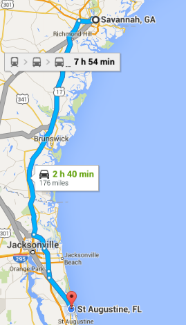
Ending mileage: 1136 Ending time: 6:30 pm
Travel mileage:  82 (can't be right) Travel time: 2:30 hours

Our first stop was the National Park Service Fort Sumter visitor center where there was an extensive exhibit of the history of Charleston from its founding in 1670 through the Civil War. The only access to Fort Sumter is via ferry from the visitor center. 

On the ferry going over, two dolphins were playing just at the bow of the ferry. We could see them just below the surface and then they would jump up and crash back into the water. They were so close they splashed the people standing in the very front of the ferry.  It was quite exciting to watch.

One of the first battles of the Revolutionary war was on a Charleston island where the militia was able to hold off the British attackers in large part due to the Palmetto Palm palisade around the fort which caused the cannon balls to bounce off and the militia then fired back the same cannon balls at the British, damaging their ships.  This is the reason the South Carolina flag (and license plates) has the Palmetto Palm on it.

Fort Sumter was built after the Revolutionary War to hold off foreign attackers from the sea and was a three-story structure. After the succession of South Carolina in 1860, the union forces held Fort Sumter  but were attacked by the confederate forces from the land which was the weaker side of the fort and the union forces were forced to evacuate (not quite surrender). The confederates held the fort until almost the end of the Civil War but it was reduced to a single story of rubble.

The fort has been restored to its single story level. When the fort is opened for tourists in the morning, one of the first acts is to raise the huge flag over the fort with the help of the visitors - it is a rather emotional experience. There are many informational exhibits and a visit to the fort is certainly worthwhile.

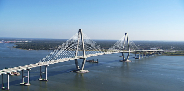
In the afternoon we took a coach tour of Charleston to see many of the historic buildings going back to the 1700s and 1800s. Many were restored after the Civil War and a major earthquake in 1898. At the end of the tour we visited the Charleston Museum which is the oldest museum in the US. We hadn't realized the importance of rice to the South Carolina economy but this is what created much of the wealth of the early landowners although it could only be done with the help of many slaves as it was very labor intensive. The end of slavery was largely responsible for the decline in rice production.

On the drive to Savannah, we were surprised by how undeveloped much of the state is - it was almost like going through the Adirondacks with miles and miles of forest with no houses - although it is VERY flat. Along the way we saw a sign for boiled peanuts and peach cider and had to stop. The peach cider was very good although sweet. A sampling of the boiled peanuts convinced me this wasn't something I wanted to buy!

We had a delicious seafood dinner at the Shrimp Factory in Savannah.

Day 5 route

Approaching Fort Sumpter

Raising the flag

Monday, April 25, 2016

Day 4, Monday, April 25 - Durham, NC to Charleston, SC

Starting mileage:  744 Starting time: 11:30 am

Ending mileage: 1054 Ending time: 4:30 pm
Travel mileage:  310 Travel time: 5:00 hours

After a relaxing breakfast with Bill and Debbie  and doing laundry, we set out for Charleston.

Fortunately, the weather is still good and the traveling down I-85. There were a number of places along the highway where different wildflowers were in bloom, mostly orange poppies and white daisies but also some blue flowers that we couldn't identify.

We are staying at a Quality Inn in Mount Pleasant, just across the river / bay from Charleston. 

We had a delicious dinner at Pearlz in the Charlestown French Quarter. Carmen had shrimp and grits which is a local specialty while I had a mixed grill with scallops, swordfish, mahi-mahi and monkfish over risotto which was very good. Afterwards we walked around the French Quarter to see some of the historic buildings and churches. Some of the streets are paved with rounded cobblestones, not the rectangular cut stones.

Day 4 route

Ravenel Bridge in Charleston
our hotel was by the right end